


- Global Streaming: Securely broadcasts live drone video and telemetry to any device.
- AI Surveillance: Active alerts for perimeter breaches and unauthorized movement.
- Secure Data: End-to-end encryption for defense and law enforcement operations.
- Universal Access: Plug-and-play control from mobile, desktop, or command centers.
Inflight.live – A platform for Live Drone Streaming & Real-Time Mission Intelligence


Yaanendriya YDx M CB-2-E 9-DoF AHRS & IMU Module
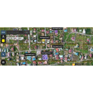
₹7,457.00 excl. GSTPIX4Dcloud: Web-Based Platform for Processing, Hosting, and Sharing Drone/Terrestrial Imagery
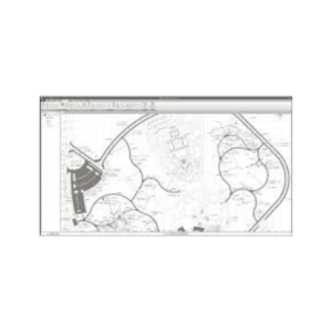
Price range: ₹116,848.20 through ₹406,704.20 excl. GSTPrice range: ₹116,848.20 through ₹406,704.20 excl. GST Select options This product has multiple variants. The options may be chosen on the product page Quick ViewPIX4Dmapper: Industry-Standard Photogrammetry Software
₹361,414.20 excl. GSTPIX4Dreact: High-Speed 2D Mapping Software
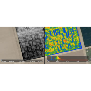
₹89,674.20 excl. GSTPIX4Dfield: Mapping Software for Aerial Crop Analysis and Digital Farming
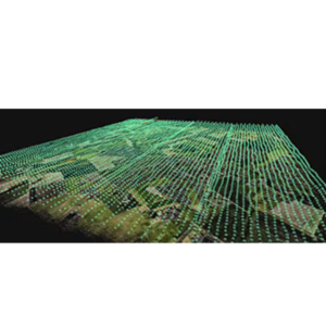
₹180,254.20 excl. GSTPIX4Dmatic: Photogrammetry Software for Professional Mapping
Price range: ₹207,428.20 through ₹451,994.20 excl. GSTPrice range: ₹207,428.20 through ₹451,994.20 excl. GST Select options This product has multiple variants. The options may be chosen on the product page Quick View- GNSS post-processing in static, PPK, PPP, and RTK modes
- Ideal for surveying, UAV, GCPs, and road engineering
- Built-in tools for converting, calculating, and managing GNSS data
- Supports GPS, GLONASS, BeiDou, and Galileo
EFIX eOffice
4
Shopping Cart (4)