Your bag is empty
Don't miss out on great deals! Start shopping or Sign in to view products added.
Shop What's New Sign in
Available in stock
The Complete Post-Processing Suite for GNSS Data Precision
EFIX eOffice is a powerful GNSS post-processing software engineered to turn raw field data into high-accuracy results. Designed for surveyors, UAV professionals, and geospatial engineers, it bridges the gap between field operations and office analysis. With support for GPS, GLONASS, BeiDou, and more, eOffice offers both static and PPK modes to meet the demands of diverse geospatial projects.
Whether you’re mapping GCPs, processing UAV trajectories, or working on road construction layouts, EFIX eOffice provides a seamless environment where precision and productivity go hand-in-hand. Its streamlined interface and cutting-edge algorithms deliver fast, accurate results, helping you meet deadlines with confidence.
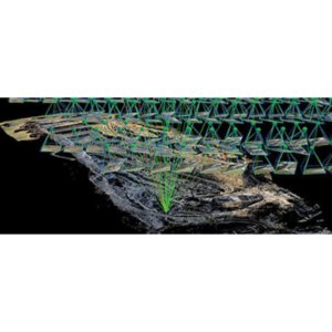
At the core of eOffice is a suite of precision-focused algorithms developed through ongoing research and development. These engines support Static, PPK, PPP, and RTK modes, ensuring that every GNSS dataset?no matter how complex?can be refined into accurate positioning outputs.
Quality control tools embedded in the workflow allow for detailed review and validation, making it ideal for professional-grade geodetic and engineering projects.
EFIX eOffice goes beyond simple post-processing. With specialized modules for UAV POS data, advanced road alignments, and high-density control networks, it becomes an indispensable tool for:
You can link data from the field directly into your post-processing workflow, minimizing conversion errors and saving time.
Working visually improves clarity and reduces error. EFIX eOffice comes with embedded GIS capabilities and online map integration, allowing you to layer and overlay vector data, features, drawings, and road alignments with ease. Each map element is presented clearly, making spatial decisions faster and more accurate.
Packed with a comprehensive set of geodetic and utility tools, EFIX eOffice is more than just post-processing software?it?s your data hub for office-based GNSS operations. Key tools include:
With this complete toolset, you can manage, review, and deliver professional-grade outputs without switching platforms.