Your bag is empty
Don't miss out on great deals! Start shopping or Sign in to view products added.
Shop What's New Sign in
Available in stock
M.R.P.: ₹85,598.10 Incl. GST
The PIX4Dcloud Educational licenses provides a powerful, web-based ecosystem for students, researchers, and professors to process and share drone and terrestrial imagery. By removing the need for high-end local hardware, this cloud platform allows academic teams to generate survey-grade 2D maps and 3D models from any device. It is specifically designed to foster collaboration, enabling users to document site progress over time and share interactive results with a simple URL. Whether used for archaeological documentation, environmental monitoring, or civil engineering coursework, PIX4Dcloud turns complex data into accessible, actionable insights.
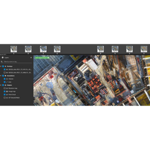
The educational version includes access to PIX4Dcloud Pro features, such as the Timeline tool, which is essential for tracking changes in a job site or natural environment across multiple dates. It features AutoGCPs, a machine-learning technology that automatically detects and marks ground control points to ensure high absolute accuracy without manual intervention. Users can also utilize 2D and 3D comparison tools, overlaying design files (DXF/IFC) against as-built conditions to teach students about quality control and precision in modern construction and surveying workflows.
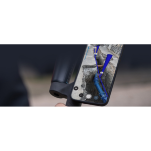
Optimized for high-capacity projects, the platform supports up to 4,000 images per dataset. The educational license is typically structured as a Professor Yearly license, which includes a generous allocation of 2,500 processing credits to support extensive research or multiple student projects. Data is stored securely in the cloud with a 2 TB storage limit, allowing for long-term project hosting and remote access. Integration with mobile tools like PIX4Dcatch allows for a seamless “capture-to-cloud” workflow, perfect for field-based learning and rapid data turnaround.
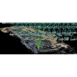
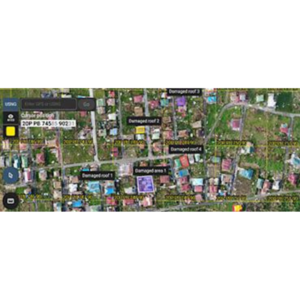
In Environmental Research, PIX4Dcloud is used to analyze terrain changes and vegetation health, with the ability to share interactive 3D models with global collaborators. University Departments use the classroom licenses to provide students with a professional platform for site documentation and job site analysis, preparing them for industry standards in BIM and GIS. Public Safety programs utilize the rapid processing capabilities to teach situational awareness and disaster response mapping, where data can be synchronized and viewed by multiple agencies in real-time.
| Feature | Specification |
| Max Images per Project | Up to 4,000 |
| Included Credits (Professor) | 2,500 Credits/Year |
| Cloud Storage | 2 TB (Fair Usage Policy) |
| Processing Speed | Cloud-based (Server-side) |
| Inputs Supported | Nadir, Oblique, Terrestrial (RGB) |
| Deliverables | Orthomosaic, DSM, Point Cloud (.LAS), 3D Mesh (.OBJ) |