Your bag is empty
Don't miss out on great deals! Start shopping or Sign in to view products added.
Shop What's New Sign in
Price range: ₹116,848.20 through ₹406,704.20 excl. GST
Available in stock
M.R.P.: ₹137,880.88 Incl. GST
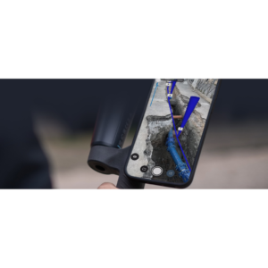
PIX4Dcloud is the premier web-based platform for processing, hosting, and sharing drone and terrestrial imagery. It eliminates the need for expensive local hardware by leveraging the power of cloud computing to generate high-resolution 2D maps and 3D models. Specifically built for construction, mining, and large-scale project management, it provides a centralized “source of truth” where teams can document site progress over time. With a simple URL, stakeholders can access survey-grade data from any browser, anywhere in the world, ensuring everyone stays on the same page without installing complex software.
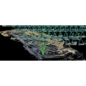
The platform features a robust photogrammetry engine that automatically transforms raw images into measurable deliverables like orthomosaics and point clouds. In the Advanced version, the Visual Timeline allows you to scroll through different capture dates to monitor site evolution instantly. You can also utilize the 2D/3D Design Overlay tool to import DXF or IFC files, allowing you to compare “as-built” reality against “as-designed” plans. For higher accuracy, the AutoGCPs functionality automatically detects ground control targets, significantly reducing manual marking time while ensuring centimeter-level precision for your exports.
PIX4Dcloud is designed for scalability, supporting projects with up to 4,000 images. It handles various data inputs, including aerial drone shots and terrestrial data captured via the PIX4Dcatch app. The interface includes built-in measurement tools for distance, area, and volume, with the ability to perform volume comparisons between different dates to track earthwork progress. It integrates seamlessly with industry-leading ecosystems like Trimble Connect and ESRI ArcGIS Online, making it easy to move your drone data into your existing CAD or GIS workflows.
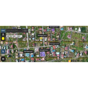
In construction management, PIX4Dcloud is used to keep subcontractors accountable and provide visual proof of progress to investors. Mining and quarrying teams use it for frequent stockpile audits and safety inspections without halting production. It is also an invaluable tool for telecom and utility companies to perform remote virtual inspections of towers or infrastructure, reducing the need for dangerous climbs or site visits. By providing a permanent, time-stamped visual archive, it also serves as a critical resource for dispute resolution and legal documentation, proving exactly what was built and when.
| Plan | Monthly, Yearly, 3 Years |
|---|---|
| Type | Starter, Pro, Enterprise |