Your bag is empty
Don't miss out on great deals! Start shopping or Sign in to view products added.
Shop What's New Sign in
Available in stock
M.R.P.: ₹106,884.40 Incl. GST
PIX4Dmapper Educational License is the industry-leading photogrammetry desktop software tailored for schools, universities, and research institutions. It serves as the definitive tool for teaching students how to transform terrestrial or aerial imagery into highly accurate, survey-grade 2D maps and 3D models. By providing full access to the “classic” photogrammetry workflow, it allows academic users to dive deep into the science of spatial data, offering complete control over every processing step—from initial triangulation to the final textured mesh.
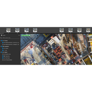
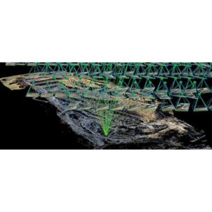
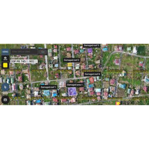
The hallmark of PIX4Dmapper is the rayCloud environment, a unique interface that connects original images to every point in the 3D reconstruction. This allows students to visually verify and manually improve the accuracy of their projects, making it an invaluable pedagogical tool for understanding the geometry of photography. The software also features automatic point cloud classification, which uses machine learning to distinguish between buildings, vegetation, and road surfaces. Additionally, the educational license includes unlimited desktop processing, allowing researchers to handle massive datasets without worrying about per-image costs.
Engineered for precision, PIX4Dmapper supports a vast range of camera types, including RGB, thermal, and multispectral sensors. It is highly flexible, allowing for the integration of Ground Control Points (GCPs) and coordinate system overrides to achieve sub-centimeter absolute accuracy. The educational suite is available in three distinct structures: the Professor license (perpetual, 2 devices), the Student license (short-term for coursework), and the Classroom license (supporting up to 25 simultaneous users), all of which include access to the Pix4D knowledge base and 50% discounts on official certifications.
In Geospatial and Civil Engineering departments, PIX4Dmapper is used to teach the fundamentals of surveying, volume calculation, and site inspection. Archaeological researchers rely on it to document heritage sites with millimeter precision, creating digital twins that can be analyzed long after the field season ends. It is also a staple in Environmental Science, where it is used to create Digital Surface Models (DSMs) for flood modeling, coastal erosion tracking, and forest canopy analysis.
Dataset Capacity (Desktop)Unlimited images
Processing WorkflowManual & Automated (rayCloud)
Supported SensorsRGB, Thermal, Multispectral
License OptionsProfessor, Student, Classroom
GPU OptimizationNVIDIA CUDA-compatible required